What is protected airspace?
It is important to consider prescribed airspace constraints when undertaking any works within the vicinity of an aerodrome (e.g. up to approx. 15 km). Crane operations in the vicinity of an airport have the potential to create air safety hazards and to seriously limit an airport’s operations.
The most basic surface is called the Obstacle Limitation Surface (OLS). It is imperative to assess the proposed activity against the relevant OLS requirements to understand the potential impacts on airspace (i.e. to incorporate maximum height requirements into the planning of projects early or to otherwise identify required permissions to penetrate the airspace).
The International Civil Aviation Organisation (ICAO) conventions delegate each country to appoint its own aviation safety authority to ensure that airspace surrounding aerodromes is kept safe, as well as to ensure the operational efficiency and regularity of aviation operations are not interrupted.
Contractors or other entities that impact on airspace can potentially be requested to remove an obstacle from protected airspace or be fined by the aviation safety authority that governs airspace if they do not comply with a direction to remove an obstacle/hazard.
In Australia, the Civil Aviation Safety Authority (CASA) is responsible for airspace protection and in the United States of America (USA) it is the Federal Aviation Administration (FAA) responsible for airspace protection. The protection of airspace has region-specific variances in many instances, however, the overall premise of OLS dimensions is consistent globally.
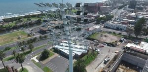
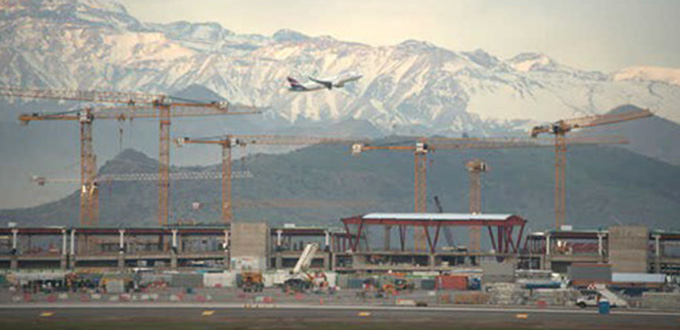
An example of cranes operating in the vicinity of an aerodrome is shown in Figure 1 (where 23 Liebherr tower cranes are being used for the airport expansion project in Santiago de Chile).
About the Obstacle Limitation Surface (OLS)
The OLS includes a series of surfaces in the airspace surrounding an airport.
The OLS defines the airspace to be protected for aircraft operating during the initial and final stages of flight, or when maneuvering in the vicinity of the airport. An example of a non-dimensioned OLS is shown in Figure 2.
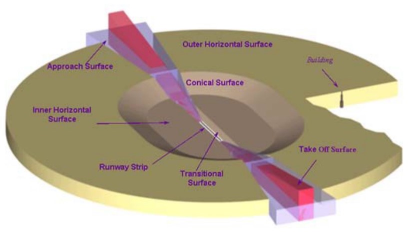
Figure 2 – Relationship of outer horizontal, conical, inner horizontal and transitional surfaces (CASA 2019)
The OLS is generally (but not always) the lowest obstacle surface and is designed to provide protection to aircraft when a pilot is flying visually (i.e. under Visual Flight Rules, “VFR”). New developments may penetrate the OLS but only in particular locations and if strict requirements are met (generally this will be based on a sound risk assessment and a requirement to highlight the obstacle via permanent lighting mechanisms etc.).
For temporary intrusions (or potential intrusions), crane operators must submit details of the crane as: Location of operation, duration of the works, height, maximum operating height, and the radius of operation for the crane.
In Australia, the airport operator obtains the crane permit/obstacle assessment request from external parties and then calculates whether the crane is penetrating or clear of the airspace. If a potential obstacle is being created, then the airport operator will need to further liaise with regulators to ensure that the risk is acceptable.
The current OLS assessment processes generally involve time-consuming processes – including collecting coordinates, identifying locations of where the operations will occur and confirming critical airspace surfaces that may be impacted. An example two-dimensional OLS drawing that is typically included in airport master plans and local government town plans is shown in Figure 3.

Figure 3 – Example of an OLS generated to cover the airspace area (Adelaide Airport)
Technology and the future of airport operations
Not only are OLS assessments a time-consuming activity, but they also require technical competence to ensure that the impacts on airspace have been calculated correctly. This involves training, testing and ongoing professional development of aerodrome employees to ensure that aviation operations are not put at risk.
Fortunately, there are now technological solutions to mitigate the risk of human error and improve the workflow of OLS assessments. Applications such as Airspace Lab (developed by software firm EngiSeek), provide this technology to facilitate the process, allowing crane operators to connect with airports (registered with the application) and request crane permits to rapidly obtain results of proposed activities from aerodrome operators within a web-based digital platform.
An example of the three-dimensional (3D) OLS which integrates with accurate terrain and aerial imagery can assist non-technical personnel to manage administration of airspace protection and allows automatic verification and live view of the results, as shown in Figure 4.

Figure 4 – Three-dimensional (3D) OLS displayed in Airspace Lab (2022)
JJ Ryan Consulting is currently working alongside Airspace Lab to deploy 3D OLS tools across the globe, whilst further developing the software product to provide other safeguarded surface management (including lighting, wind shear, wildlife hazard and more).
Airspace Lab (2022): EngiSeek’s Airspace Lab tool for managing airspace risks: https://airspacelab.com/
CASA (2019): Civil Aviation Safety Authority, Manual of Standard Part 139 – Aerodromes: https://www.legislation.gov.au/Details/F2020C00797/Download

