Total Station Survey (TSS) and Global Navigation Satellite System-(GNSS) and are two traditional surveying methods that are used to determine precise positions on the Earth’s surface. Both methods have their own advantages and disadvantages, and they are often used in conjunction with one another to achieve the most accurate results.
GNSS (per its name) uses network of satellites to determine the location of a receiver on the ground. The most well-known GNSS system is the Global Positioning System-(GPS) , which is operated by the United States government, however Russia’s Global Navigation Satellite System (GLONASS), China’s BeiDou Navigation Satellite System, and the European Union’s Galileo are other fully operational GNSSs.
GNSS receivers can provide positions with an accuracy of about 3-5 metres without localised accuracy improvement. Accuracy can be improved through the use of differential correction techniques such as the Real-Time Kinetic (RTK) technique which uses telephone carrier-based ranging that are orders of magnitude more precise than those available through code-based positioning.
GNSS is particularly useful for large-scale surveys, as well as for applications that require real-time positioning, such as navigation and asset tracking. With an RTK, GNSS surveys can be accurate to approximately +/- 20-30mm.
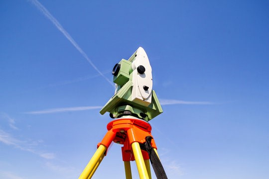
TSS uses a combination of electronic distance measurement and angular measurement to determine positions on the ground. The Total Station instrument is typically mounted on a tripod, uses a laser or infrared beam to measure distances to a reflector or target placed at a known location. It also measures angles using an electronic theodolite. The Total Station instrument also uses these measurements to determine positions on the ground. With an experienced surveyor and the correct equipment, accuracy can be up to +/- 2-3mm. This method is widely used in engineering and construction, as well as in land surveying and mapping. An example of a Total Station is shown in Figure 1.

Figure 1 – Example of a Total Station on a Tripod
In recent years, new laser scanning methods have been developed that have the ability to capture much more detailed information about the surveyed area. These methods use a laser scanner to rapidly and accurately capture millions of points on the surface of an object or environment. The resulting point cloud can be used to create detailed 3D models, which can be used for a variety of applications, such as architectural and engineering design, construction, and cultural heritage preservation. These laser scans can have an accuracy of up to +/- 5-10mm.
One of the key advantages of laser scanning over traditional methods is that it can capture much more detailed information in a shorter amount of time. For example, a single scan can capture millions of points on the surface of an object, while traditional methods may require hundreds or thousands of individual measurements to achieve the same level of detail. Additionally, laser scanning can be used to capture data in difficult-to-access areas, such as inside buildings or underground. An example of laser scanner outputs are shown in Figure 2.

Figure 2 – Outputs from JJR’s Laser Scanner
Laser scanning can provide high-resolution, accurate and detailed 3D models of any surveyed area, which is a valuable tool for many different applications. This can be used to create architectural designs, engineering plans, and to visualize the environment for planning, simulation, and analysis purposes.
TSS and GNSS Survey are more traditional methods for determining precise positions on the Earth’s surface. Both have their own advantages and disadvantages, and they are often used in conjunction with one another to achieve the most accurate results.
Newer laser scanning methods have recently been developed that can capture much more detailed information about the surveyed area and provide high-resolution, accurate and detailed 3D models of the area, with the added advantages of being faster and more versatile than the traditional methods.
A summary of typical accuracies, strengths and limitations is provided in Table 1 for reference.
Table 1 – Summary of Strengths and Limitations for Alternative Survey Methods
| Types | Typical Accuracy | Strengths | Limitations |
|---|---|---|---|
|
Total Station |
+/- 2-3mm |
Best accuracy Traditional method with known procedures to achieve outcomes |
Longer time to survey Old systems required two operators, but now with total robotic stations this can reduce labour costs |
|
GNSS + RTK
|
+/- 20-30mm
|
Faster than Total Station Can be completed by one surveyor relatively easily |
Without RTK support, accuracy is not good for design work Less accurate than total station |
|
Laser Scanner
|
+/- 5-10mm
|
Fastest mode of data collection Traceability of the entire site (rather than just discrete features) |
New technology Areas with limited features is difficult to complete desktop data reduction |